Homeward bound final part: Saint Petersburg to London!

Distance: 2,600km (1,615 miles)
Travel time: 37.5 hours
Mode of transport: Three trains and three buses

We just got home. Stepped off the Eurostar from Brussels and there we were: back in St. Pancras station again. This is where we started our trip eleven months ago, and the two photos at the bottom of this post are a neat reminder of what eleven months in Asia does to you. We are both hoping to maintain our new-found leanness through a rigorous programme of exercise and diet… Let’s see how that goes.

Anyway, this is just a very short post to prove to you all that we really have gone all the way from Hong Kong to London overland – a total distance of roughly 15,000km (9,300 miles). The final bit – a whirlwind tour through four European cities with barely a moment to catch our breath – was mostly about getting home and not really about seeing the sights. First there was a bus from Saint Petersburg to lovely Riga, capital of Latvia. Last time James was here it was with Lehna and involved significantly more cheap Eastern European beer. This time it was one night and a morning, with just enough time to explore the old town before catching our next bus south.
20140724-213406-77646914.jpg20140724-213406-77646534.jpg
A bus from Riga to Vilnius (capital of Lithuania) was followed in quick succession by another to Poland’s capital, Warsaw. We allowed ourselves a couple of nights to recuperate, though even in relatively cheap Poland we were constantly aware that we were spending so much more money here than anywhere else on the trip.
20140724-213510-77710571.jpg20140724-213509-77709996.jpg
After Warsaw we treated ourselves to the most luxurious sleeper train we have taken all year. Instead of the usual arrangement where we share with up to six other strangers and their children, this time we had a cabin all to ourselves. Bliss. We watched Poland end and Germany begin over a bottle of wine and some celebratory m&ms. We were both fast asleep by 10pm but woken again shortly afterwards by a burly German customs official asking us if we were carrying zigaretten. Anyway, this morning we were woken at 5.45am with coffee and a croissant, as we were about to pull into Cologne station.

Cologne’s has to be one of the best located stations in the world. We had less than two hours before another train to Brussels, and in that time we managed to sit and watch the sun come up behind the amazing stained glass windows of the gothic cathedral. This was followed by a traditional German frühstuck of sausages and mustard.
20140724-213630-77790407.jpg20140724-213629-77789862.jpg
By 8am we were already speeding towards Belgium, where we had a whole day in Brussels. We were struck by how international the city felt, but to be honest it all felt decidedly unexotic coming so soon after Uzbekistan and the like. Poor Brussels! Not that we didn’t make the most of our time there: frites, chocolate and lots of photos of manneken pis.
20140724-213736-77856725.jpg20140724-213737-77857772.jpg20140724-213737-77857357.jpg
So here we are back in London. If you want to see the route we’ve taken (last updated in Warsaw) you can see our map. For some reason it always zooms in on London first, but if you zoom right out you should be able to see our entire route. The red lines show you the route we’ve taken over the last two months to get from Hong Kong to London.

We were going to try to address the important question of how it feels to be back, but that’s probably for another post or more likely for when we see you all face to face very soon. We will sign off with the promised before and after photos. Spot the difference!20140724-222711-80831679.jpg20140724-222739-80859169.jpg

Homeward bound part 6: Tashkent to Saint Petersburg

Distance: 4,040km (2,510 miles)
Travel time: 75 hours
Mode of transport: One taxi, one minibus and two sleeper trains

For our final ‘Stan we headed north from Tashkent to the home of endless steppe and Borat: Kazakhstan. Unfortunately we are pretty much out of time now, so we had just 36 hours to experience the country before catching a mammoth train to Moscow (see below).

So, how to sum up one of the world’s largest countries on the basis of a day and a half in Shymkent, a provincial Kazakh city? Let’s start with the hotel, which was probably one of the strangest of the entire trip. It was located in a gloomy shopping mall that seemed to specialise in wedding dress shops, meaning that whenever we walked to or from our room out of hours we had to pass row after row of strange disembodied meringues in half-lit shop windows. The room itself was a bit like a 70s office set up with partitions as walls and way-too much cheap plastic and glass. It took 26 hours of continuous air conditioning before the room finally cooled to a comfortable temperature. Needless to say we spent much of our time elsewhere.

Shymkent (and the rest of Kazakhstan for all we know) was a clean, relatively modern city with friendly people, lots of pavement cafés and a bustling bazaar. Central Asia this most definitely is, but as for the brand of Central Asia portrayed by Borat – we couldn’t find any evidence. In fact, if Borat existed he would feel much more at home in parts of Uzbekistan and Kyrgyzstan, where things are altogether weirder. Our day buying train supplies in Shymkent – mainly ‘just add water’ affairs but also plenty of fruit and veg – led to some lovely interactions with locals at the bazaar, where it was clear that foreigners are rare but welcome.

That evening we made our way to Shymkent train station, where we were due to board the four-day train that would take us all the way to Europe. Excited, apprehensive, nervous: these are the things that you always feel before taking a night train. But we were prepared, and we had all the food we would need to see us through various hypothecated crises (nothing available at stations en-route, restaurant car food disgusting/overpriced, multiple border crossings leave us without any legal currency) including several pots of smash and the all-important tea bags. And when our train rolled in at 9.15pm we were pleasantly surprised to find ourselves in a comfortable cabin and sharing with two Kazakh guys – both friendly and neither a loud sleeper. And so it was that we settled down to lots of reading, catching up on diaries, playing card games and staring out of windows at endless desert and steppe.
20140720-222514-80714342.jpg20140720-222513-80713983.jpg20140720-222514-80714748.jpg
Though when we come to think of it, quite a lot happened to break the journey. First, on our second day on the train, we passed what remains of the Aral Sea. The Soviets in their unending wisdom decided that Central Asia would be a good place to grow cotton, and that the rivers feeding the Aral Sea would be a good source of water to irrigate the new crops. Several decades later, this has created a man made environmental catastrophe on an unprecedented scale, with previously thriving fishing ports now hundreds of kilometres away from the receding shoreline of the Aral.

The Kazakh government has managed to revive its half of the Aral Sea by building a large damn to separate it from the Uzbek side (the Uzbek government continue to use the Aral’s waters to feed their appalling cotton industry, thereby consigning the Uzbek half of the sea to history). But even in Kazakhstan things are by no means back to normal: our train stopped at a down called Aral, where James had just enough time to jump off and take a picture of a mural in the station that depicts locals sending fish up to Russia to help peasants through a famine. Aral town is now 20km away from its namesake the Aral Sea, and the cranes of its once-busy fishing port now provides shelter for camels. The photos below show a slither of the Aral that we spotted earlier that day, some salt flats that were once sea bed, the mural in Aralsk station, and some wandering camels that we spotted in the middle of nowhere.
20140720-222850-80930327.jpg20140720-222849-80929899.jpg20140720-222901-80941479.jpg20140720-222902-80942023.jpg
The four of us in our cabin also found ourselves caught up in some kind of international melon-smuggling operation. The train conductor and his son managed to acquire a large quantity of fine looking melons when we stopped at the Kazakh town of Arys. These were stored in our cabin for safekeeping, with the result that we were regularly interrupted by various train crew demonstrating the firmness and curvature of their melons to prospective customers. When we crossed the border into Russia this activity became more regular and disruptive, to the extent that we were being woken up in the middle of the night by clandestine melon-dealing, our foreignness (we suspect) being used as cover by nervous train-conductors-cum-tropical-fruit-smugglers.
20140720-222731-80851710.jpg
Our daily quest to eat a reasonably balanced meal also helped to break up the monotony of the train journey. All trains in the former Soviet Union have samovars so we had endless supplies of hot water for our smash (breakfast), pot noodles (lunch) and cups of tea (all day). This was supplemented by fruit (no melons unfortunately), vegetables, chocolate and a big jar of pickled gherkins that we had brought from Shymkent. A daily meal in the train’s restaurant car and some fresh bread that we found at a station somewhere in the northwest of Kazakhstan kept us active. Paying for the latter required a withdrawal from an unlikely ATM found on the station platform. It’s odd that Santander regularly block our bank cards when we make withdrawals in Bangkok or Kuala Lumpur but seem absolutely fine with a withdrawal from a tiny town with no road access in deepest darkest Kazakhstan!
20140720-222331-80611478.jpg20140720-222330-80610341.jpg20140720-222331-80611103.jpg20140720-222330-80610725.jpg
What about cold beer we hear you all ask? Well it turns out that alcohol is now banned on Kazakh and Russian trains. James found this out the hard way. He bought a bottle from a station platform, drank it with a little help from Heather, and then went to throw away the bottle in the bin at end of the carriage. We were getting close to the Russian border at this point so there were lots of undercover police with sniffer dogs on board. One of the former spotted the bottle and – thinking James was Kazakh or Russian – asked to see his ID card. By the time he realised that James doesn’t speak Russian (and therefore more bother than he’s worth) it was too late. Luckily we got away with just a brusque passport check, a once over sniff-test from the Alsatian, and a warning from a co-passenger that clarified what James had done wrong: “Beer. No.”

One final thing that staved the boredom: three border crossings. In a previous post we mentioned the arbitrary nature of many Central Asian borders, and this is also the case with the 6,846km border between Russia and Kazakhstan. To get to Moscow our train had to leave Kazakhstan and enter Russia, then turn back into Kazakhstan again, and then finally leave Kazakhstan for good. We were apprehensive about these multiple crossings because technically we didn’t have enough visas in our passports, but on this occasion border guards on both sides seem to be using common sense and things worked out fine.
20140720-225223-82343829.jpg
We are sure that older readers of this blog, some of whom did a bit of travelling in their own time, will often think that we’ve to it easy nowadays what with cheap flights, iPads and ATMs. But one thing hasn’t changed: there is something uniquely frightening about crossing obscure international borders by train in the middle of the night. The train grinds to a halt, with nothing but pitch black darkness outside, and all of a sudden the corridors outside the compartments are filled with armed guards, customs officials and sniffer dogs. Everyone is bleary eyed with sleep and dare not get up for the toilet or even remove the sheets to appear presentable. A bang on the door is all it takes to wake up anyone who has managed to sleep through to this point. The door slides open and an extremely unfriendly-looking man will do his utmost to act the part of Bond-villain or Gestapo from a dodgy WW2 film, with a shout of “PASSPORTS” in a thick accent. Things normally turn out fine but we have rarely felt more vulnerable than at times like these.

The end of Asia and the beginning of Europe was marked by the crossing of the Ural river near the Kazakh city of Uralsk (who knew that a bit of Kazakhstan is in Europe?). I’m not sure what we were expecting but ‘the other side’ – Europe that is – was quite underwhelming. It took another day or so for the scenery to become more familiar, and by the time we were approaching Moscow the countryside could almost have been Leicestershire: rolling green fields and deciduous forest where just yesterday there had been desert and steppe.

If we had any doubts that this was really Europe, arriving in Moscow itself dispelled them all instantly. It’s an odd time to be here, what with a terrible metro crash the day before we arrived, the upping of sanctions by the US and Europe, and now the shooting down of MH17 – but to be completely honest, we didn’t notice anything out of the ordinary during our stay in the city and spent our time visiting the Red Square and eating health food of the sort that we have been craving for so long in Central Asia. We also got to see Lenin in his mausoleum, a monument to Stalin next to the Kremlin, and a Putin lookalike doing the rounds!
20140720-222513-80713563.jpg20140720-223223-81143832.jpg20140720-223222-81142931.jpg20140720-223224-81144271.jpg20140720-223223-81143404.jpg
In Saint Petersburg, our next stop north of Moscow, we were plunged back into the world of grand European architecture and world-class museums (in the Hermitage it was odd to see artefacts plundered from many of the locations we’ve visited this year), and it suddenly felt like we were InterRailing around Europe again rather than spending a year in Asia. Sleeping was difficult as it barely gets dark at all here during Summer, but when we woke up we knew that we would be able to find decent coffee, orange juice and a croissant or two – what luxuries!

The anonymity of being a couple of Caucasians in two largely-Caucasian cities was both novel and welcome after almost eleven months of constantly sticking out in a crowd. Being back in Europe was strange for us. We kept noticing what people were wearing (not much in the summer heat), the shapes of their bodies (rotundness not being a common feature amongst the countries we’ve visited recently), the prices they were paying for their cappuccinos and sushi (higher than even London and astronomical compared with anywhere in Asia) and the constant chattering on and fiddling with smartphones. We also realised that we would probably both be doing these things again in the very near future, apart from (we hope) the rotundness!20140720-225422-82462993.jpg

Our final slice of Asia: Uzbekistan’s Silk Road cities

The next two weeks will largely consist of a series of back-to-back train and bus rides. We will dutifully report everything here as we have been doing so far, but let’s be honest: it won’t be the most exotic part of the trip. So, in a last ditch attempt to keep our faithful readers reading until the end, here is a final slice of Asian exotica to (hopefully) delight and entertain.

Having reached Tashkent (see last blog post) we set out to explore Uzbekistan’s famous Silk Road cities: Khiva, Bukhara and Samarkand.

Our first stop was Khiva, situated in the west of Uzbekistan in the middle of the Kyzylkum desert. There really is nowhere else quite like it: a perfectly-preserved medieval desert city complete with mud ramparts. To our limited minds the grand exotic architecture evoked Aladdin, magic carpets and camel trains, while the maze of dusty lanes and mud-built houses felt like a scene from the nativity.

The amazing thing is that Khiva was still a fully-functioning independent “khanate” right up until the early twentieth century. Convicted criminals were still being tied up in sacks and thrown from minarets, while the historically-thriving slave bazaar didn’t completely peter out until the Bolsheviks took power in the 1920s. We could clearly make out the alcoves in the city’s east gatehouse where newly captured Persian or Russian slaves were displayed for sale.

After being annexed by the Russians in the late nineteenth century, Khiva managed to survive for a few more decades before it’s powers were taken away and it’s streets emptied of citizens. Today it is a museum: Khivans themselves live in a new town outside of the walls, giving the old city a rather deserted atmosphere, heightened during our visit due to the extreme summer heat and consequent lack of visitors.

The tile work here is stunning, whether adorning a minaret, decorating the interior wall of a private mosque or throne room, or livening up the gates of austere sand-coloured medressas (Islamic places of learning). The minarets were the absolute highlight for us, probably due to the effect of bright blue tiles against the brown and grey desert scenery. One of the best things about Khiva is that you can stay in a traditional Khivan home within the city walls and enjoy the all of this after the tour groups and hawkers have gone home!

20140710-112017-40817315.jpg
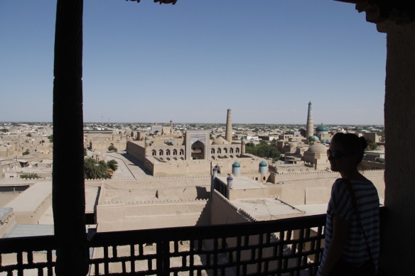
Above – Heather views Khiva from a watchtower on the mud walls
Below – A policeman enters the west gate of the old city20140710-112153-40913556.jpg20140710-112416-41056827.jpg
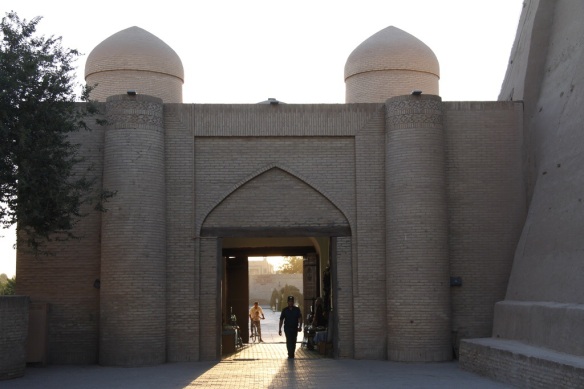
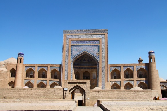
Above – The Kutlimurodinok Medressa
Below – Traditional blue and white tiling in the Tosh-hovli Palace (spot the accordion)20140710-112618-41178222.jpg20140710-112825-41305845.jpg
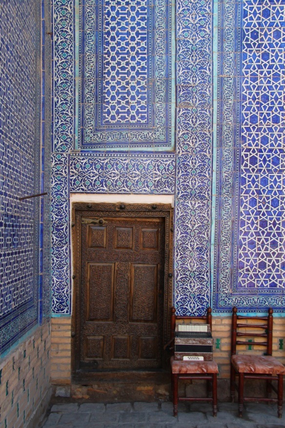
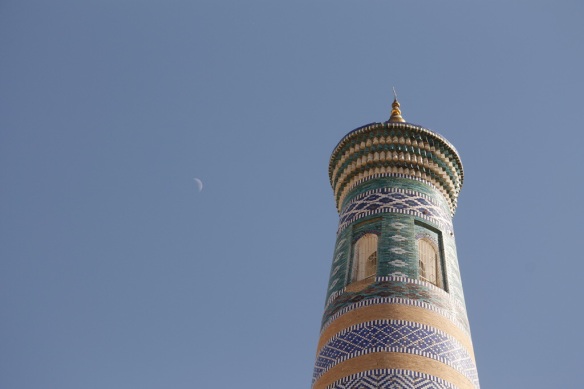
Above – The Islam-Hoja minaret
Below – Traditional musical instruments for sale on a Khivan street20140710-113119-41479109.jpg20140710-113155-41515619.jpg
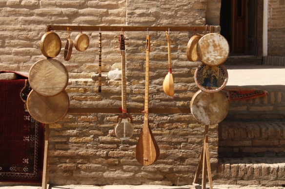
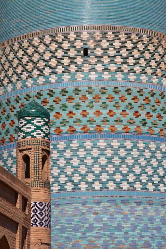
Above – Little(ish) and large: a Medressa in front of the colossal tiled Kalta Minor minaret
Below – Relaxing on the mud roof of our guesthouse at sunset. Khiva’s medieval mud-built walls are behind us20140710-113353-41633876.jpg

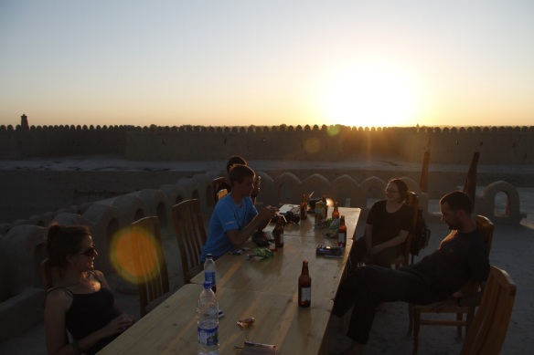
Next we made our way east through some of the driest and hottest landscapes we have seen on this trip – to the holy city of Bukhara. Bukhara is larger than Khiva and historically more important as a place of Islamic pilgrimage, religious education and Silk Road trade. The buildings are grander and more spread out, interspersed with scrappy but interesting bits of old town where actual Bukharans still live and work.

Thankfully we didn’t get the same welcome as a pair of British travellers who preceded us back in the 1840s. Colonel Charles Stoddart and Captain Arthur Conolley, amongst the very few Europeans who had seen legendary Bukhara at that time, were kept in the infamous ‘bug pit’ for months with only rats, lice and cockroaches for company (in a move that would later inspire the makers of I’m a Celebrity, Get me out of Here). Finally they were dragged out in front of the Emir’s subjects, made to dig their own graves, and then beheaded. In short, Bukhara’s despotic Emirs were famous for their elaborate and sadistic punishments and, like Khiva, their economic reliance on the slave trade.

Many of the individual buildings in Bukhara clearly surpass anything in Khiva both in terms of grandiosity and scale. But we felt that some of the renovations and more aggressive attempts to make the town tour group-friendly had sapped some of its soul. A good example is the famous Lyabi Hauz public square. The space has been desecrated in recent years by fake plastic camels, a bouncy-castle Medressa, a chintzy scale model of Bukhara (in use as a floating duck house), and a series of gaudy plastic storks adorning the ancient mulberry trees (Bukhara’s real-life storks all left the city after the Soviets drained the canals and pools). It becomes quite difficult to appreciate the elegant architecture in amongst all this cheap crap – to the extent that we barely took any photos in that area at all.

On the other hand, some of the other buildings in Bukhara are just spectacular. Immaculately preserved covered bazaars, beautiful medressas (some of which are still in use), and of course the Kalon mosque and minaret. And it didn’t take much to escape touristville. One morning, in search of fresh fruit and vegetables, we made our way to a large modern bazaar in the Russian part of the city. Within five minutes a sweet lady who was at the same fruit stall as us had insisted on paying for our bag of plums in a Ramadan-inspired act of generosity. She also filled our hands with fruit pastilles and tried to give us her bag of recently-purchased apples!

20140710-114404-42244840.jpg
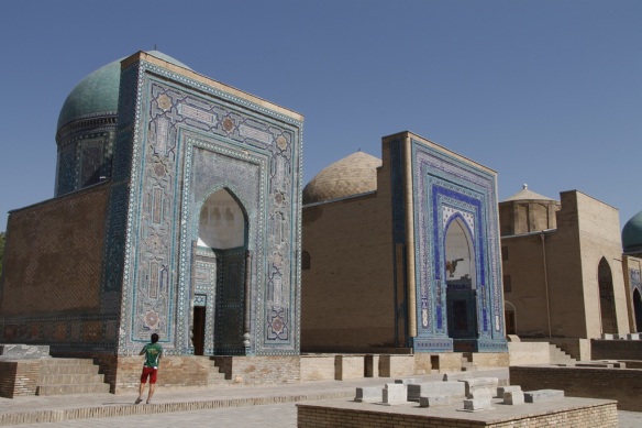
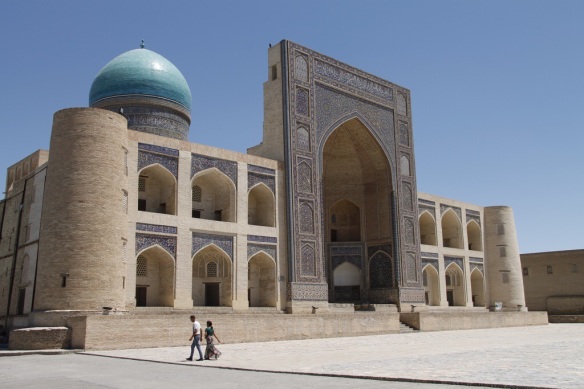
Above – The Mir-i-Arab Medressa
Below – Char Minor20140710-114546-42346095.jpg20140710-114625-42385281.jpg
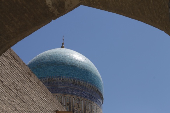
Above – Blue dome of the Kalon mosque
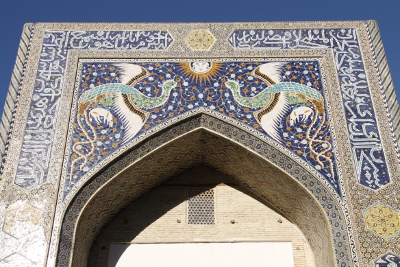
Below – Tile work of the Nadir Divanbegi Medressa, depicting a pair of peacocks holding lambs either side of a sun with a human face
20140710-114810-42490920.jpg20140710-115048-42648114.jpg
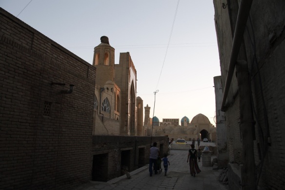
Above – Bukhara at dusk

Finally, we took the “golden road to Samarkand”. Well, we took the train. Samarkand has to be the most evocative Silk Road place name of them all, and in fact it’s where it all started for this region. Tamerlane, responsible for restoring the glories of Ghengis Khan’s Mongol Empire, was born here in 1336. His descendants went on to conquer much of Central Asia and Northern India and Samarkand was, for centuries, their capital.

Today Samarkand is a fairly big city by Uzbek standards, with pleasant green spaces and a Russian town that’s actually nice to be in. It’s size makes it feel completely different to Khiva or Bukhara, though unfortunately city planners have been busy erecting ugly walls to separate the big tourist sights from the fascinating and still lived-in old town that surround them. It kind of feels like custom-made fitted wardrobes but for a city.

The most famous sight here and anywhere in Central Asia is the Registan, a huge public square flanked on three sides by some of the oldest, largest and most opulent Islamic buildings anywhere on the planet. Unfortunately we found our visit to be quite flat, mainly because the authorities have allowed tacky tourist shops to fill all of the nooks and crannies of these amazing buildings. Aggressive sales tactics meant that we couldn’t ignore this – some shops had even displayed their wares in cabinets around exhibits within the museums!

Elsewhere in the city we did like the Gur-i-Amir mausoleum for its blue-fluted dome and for the fact that it was just two minutes walk from our guesthouse. The Shah-i-Zinda cemetery was also a fascinating and beautiful place to walk – though not for long in this heat. As you will see from the photos there are actual normal people living here as well, which means that there was a bit more going on at night and even some tasty food options (a rarity in Central Asia).

20140710-150853-54533536.jpgAbove – Tiled facades of the mausoleums at the Shah-i-Zinda cemetery
Below – Interior of one of the Shah-i-Zinda mausoleums20140710-151036-54636729.jpg20140710-151145-54705054.jpg
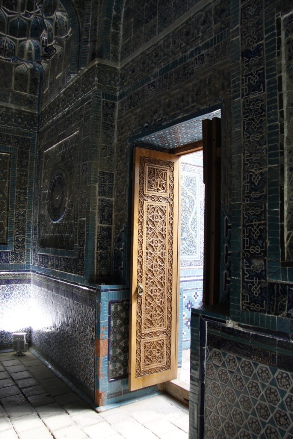
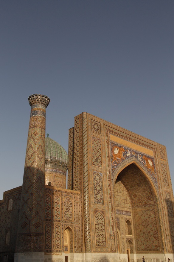
Above – The Sher Dor Medressa on The Registan (the tigers are actually lions)
Below – Enjoying some shady downtime in a Medressa courtyard20140710-151810-55090962.jpg20140710-151835-55115742.jpg
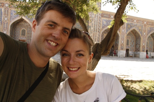
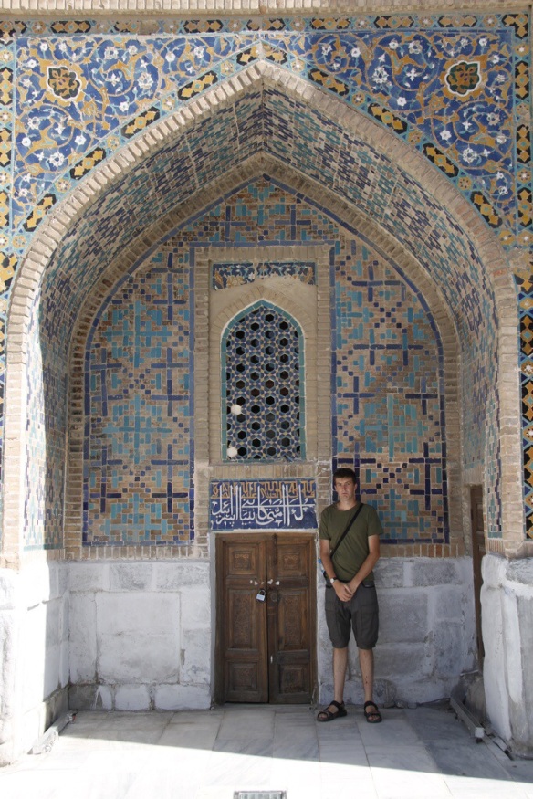
Above – James struggles to come to terms with one aspect of the local Islamic architecture
Below – The spectacular Gur-i-Amir mausoleum20140710-151918-55158391.jpg20140710-151936-55176873.jpg
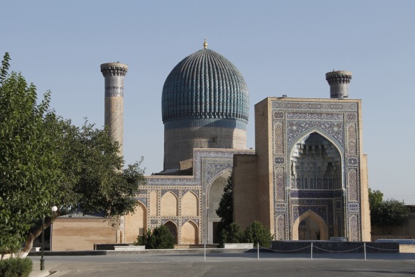
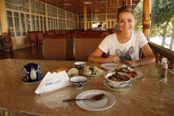
Above – Heather enjoys a rare injection of vitamin C in the form of tomato salad. We also have meat dumplings (manty), noodle soup (laghman) and the ubiquitous pot of black chai
Below – The locals enjoy a classy sound and light show at the fountain20140710-152019-55219370.jpg

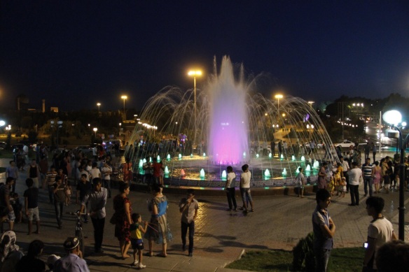
More photos (mostly of buildings)…

Khiva: http://www.flickr.com/photos/100848910@N08/sets/72157645503789012
Bukhara: http://www.flickr.com/photos/100848910@N08/sets/72157645538568906
Samarkand: http://www.flickr.com/photos/100848910@N08/sets/72157645596023362

n.b. We’ve actually got about 1,500km of Asia still to cover but we won’t have much of an opportunity to immerse ourselves in it as we’ll be stuck on a train. What the hell you do with four days and three nights on a single train will be the subject of our next blog post, by which point we will hopefully be in European Russia!

Homeward bound part 5: Bishkek to Tashkent the hard way

Distance: 1,058km (657miles)
Travel time: 24 hours
Mode of transport: Four shared taxis and three marshrutka

Bishkek and Tashkent, capital cities of Kyrgyzstan and Uzbekistan respectively, are linked by modern highways and fast rail links that should make travelling between them straightforward. Until you look at a map that is. To get from Kyrgyzstan to Uzbekistan you have to cross Kazakhstan. This is fine if you are a local but requires a Kazakh visa if you are a foreigner. Instead we would have to go about 600km south to the Kyrgyz city of Osh, cross the border into Uzbekistan there, and then travel 400km or so north again to Tashkent. This is just one of many examples of absurd borders in Central Asia, almost all of which are a result of petty politics under the old USSR. As we were soon to find out, nowhere is this more apparent than in the Fergana Valley area.

Having pre-booked seats in a shared taxi to Osh, we were collected at 8:30am from our Bishkek guesthouse. However due to some mix-up which we never got to the bottom of, the driver took until 11:15 to collect the remaining passengers. We spent much of the time sat in the back of a sweaty people carrier whilst he made a succession of increasingly fraught phone calls. The other passengers were (in order of pick-up): a young man wearing a Malboro straw hat; a young woman who spoke excellent English and a another young man who was bringing a large wooden crib with him. The crib was so large in fact, that it wouldn’t fit in the seat allotted for it and instead, had to be rather precariously secured to the roof of the car.

Our full car left Bishkek nearly three hours after we’d got in. But within 10 minutes we were pulled over by a corrupt police officer who demanded a sizeable bribe for the crib-on-a-roof contravention of Krygyz traffic law. Our driver took the tactic of calmly and patiently waiting until the bribe reduced at five minute intervals. In the quarter of an hour we spent pulled over, the two policemen pulled over an average of one car a minute. Many drivers simply handed a bank note out of the window and carried on driving. Our driver settled on 500 som (about £4) and then carried on as before: the crib remained in situ.

The next eight hours of driving were mostly uncomfortably hot, but also had some amazing views from mountain passes and over yurt-dotted meadows. We even picked up a yurt-dwelling passenger for a couple of hours – you can see the yurt where she was dropped in the photo below. However lovely the scenery is, we should point out that it makes no sense at all for a road from Bishkek to Osh to cross this kind of territory when there is a perfectly serviceable and much flatter route further west. The problem is that the better route dips in and out of Uzbekistan several times, making it useless for foreigners and logistically annoying for locals. Instead, a brand new road had to be built from scratch after the break up of the Soviet Union so that Kyrgyzstan’s two largest cities could be linked without leaving Kyrgyz territory!
20140707-141209-51129699.jpg20140707-141210-51130039.jpg
As unpleasant as long shared taxi journeys tend to be, this particular one was unusual in that all the other passengers were around our age. Stopping for lunch in the late afternoon, we were able to have a decent conversation with them thanks to Lira’s English skills (the young woman). We covered the usual topics. Were we married? Why not? Did we have children? Why not? And eventually, but inevitably: How much do things cost in England? The award for ‘most difficult to answer’ question goes to: What is the difference between an American person and a British person? Cue James trying to explain the concept of a stiff upper lip to a group of baffled Kyrgyz men.
20140707-141332-51212879.jpg20140707-141332-51212458.jpg
We’d decided to break our journey with a couple of nights in the wonderfully named Arslanbob. James spent a good fifteen minutes of childish sniggering when he realised it was genuinely pronounced ARSE-LAN-BOB – in his opinion, this is the funniest word since the Indonesian for cement. We arrived at the road junction to Arslanbob just as the sun was setting and were eventually met by another taxi to take us up to the town. Many exchanges of salom and wads of 1,000 som notes were made, and we were successfully transferred. Only one issue. We were being driven by a ten year old boy. In the dark. With no working headlights. Dad sat in the passenger seat, occasionally pointing out errant donkeys stood in the road, but mostly counting his money and snoozing. You learn many odd things during a year out in Asia: our latest is that donkey’s are incredibly difficult to spot in the dark!

By the time we got there we were in a thoroughly bad mood, having left our guesthouse in Bishkek over 13 hours earlier. We were dropped off at a homestay where a band of timid children paused to watch us haul our rucksacks up the stairs to the “guest bedroom”. James disappeared to find the toilets and on his way back was asked by the owner if he’d like a cup of tea before bed. Five minutes later we were served this:
20140707-141439-51279386.jpg
Arslanbob is famous not just for its hilarious name but also for its produce, for surrounding the village is the world’s largest walnut forest. Harvest time isn’t until September and the village seemed particularly sleepy in late June’s summer heat. We mostly did nothing apart from relax in the garden of our homestay and make short, sweaty walks up to the market place and back to drink tea with the locals in a chaikana (tea house). Back at the homestay we were continually plied with more food, including a delicious dish called dimlama which came with such rare treats as green vegetables!
20140707-141722-51442526.jpg20140707-141723-51443087.jpg20140707-142504-51904930.jpg
Two days later, refreshed and well-fed, we continued our journey towards Osh and the Uzbek border post. This time we travelled under our own steam: this required taking three separate marshrutka but is much preferable than being at the mercy of Kyrgyz taxi drivers. Osh has little to recommend it in the guidebooks but we much preferred this more genuine Central Asian town to dull and Russified Bishkek. The parks were full, the Kyrgyz felt hats were aplenty (see picture below) and we even found a Turkish restaurant that sold… wait for it… OLIVES! Our last couple of days in Kyrgyzstan were therefore pleasant but uneventful, and gave us plenty of time to over-worry about the upcoming border crossing into Uzbekistan.
20140707-142557-51957802.jpg20140707-142558-51958324.jpg20140707-142724-52044678.jpg20140707-142803-52083827.jpg20140707-142835-52115931.jpg
You may recall from earlier blog posts that getting our Uzbek visas was a challenge, to say the least. Uzbekistan is home to some of the best-preserved Silk Road cities of them all – Khiva, Bukhara, Samarkand – but despite this (or maybe because of it) the Uzbek government makes it as difficult as possible for foreigners to visit. We had heard ominous tidings from other travellers about the border crossing from Osh to Andijon (the closest Uzbek city) and so it was with trepidation that we travelled to the border on the morning of the 1st July. Crossing land borders on foot is always an odd experience, but this one felt stranger still for the total lack of signage or other information to tell us where to go. Getting out of Kyrgyzstan was the easy bit – all smiles and goodwill from the soldiers and border guards. But no-man’s land (the bit of land where you have technically left one country and not entered the other) was deserted.

Eventually we reached a big metal fence that marked the actual border. An Uzbek soldier checked each of our passports carefully and Heather shifted into charm offensive mode (her aim seems to be to make at least one soldier smile in each country we have visited). We were allowed to enter Uzbek territory but still had to make it through passport control and customs. The official behind the passport control booth studied our passports and visas for a good five minute before stamping us in. And then the real fun began. Uzbek customs. These guys are notorious for corruption and making trouble at any opportunity. As we approached, one customs guard was searching through a man’s bag and found some large boxes of cigarettes. A short conversation ended with the customs official taking one box of cigarettes for himself and waiving the rest through.

First we had to complete a complicated customs declaration form that included sections on foreign currency, valuables and even medicines and gifts that we had brought with us from other countries. This resulted in us declaring, amongst other things, some Kyrgyz felt hats, our MP3 players and ipad, two cameras, 1,200 US dollars, 200,000 Uzbek som, two boxes of black tea, and a first aid kit. Heather spent at least ten minutes taking one official through the contents of our first aid kit, trying in vain to explain the difference between antibiotics, antacids, immodium and anti-nausea tablets. To every line of questioning in Uzbek and Russian she resorted to miming a stomach ache. Every border guard in the vicinity must have come away from the conversation with the idea that we both have the shits. When it came to the Kyrgyz hats James didn’t really know what to say. He panicked, mumbled something, and for some reason settled on: “they are a gift for my girlfriend’s father”. The guard didn’t seem satisfied. “You do not have national hats in England?” James replied that regrettably we didn’t, bowler hats having been fazed out many years ago. The gamble paid off: the guard looked shocked, saddened and satisfied that the hats were going to a good cause!

Next our bags were scanned and had to be completely unpacked. We managed to hide the guns and drugs but were less successful with our books. Uzbek customs officials often confiscate any books containing maps or local history because of the risk that they won’t conform with Uzbekistan’s draconian censorship laws so we had to be careful here. Heather is reading Tolstoy’s Anna Karenina, a Russian classic that seemed to go down well with the burley border guards, one of whom thought for a moment and then exclaimed, in a deep voice with thick Russian accent, that “it is a very sad book”. On the other hand, James is reading a book about the Silk Road – full of the kind of maps and history that the customs officials were looking for. Cue second panic-lie of the day: “it’s a book about England. English history.” The guard considers this as he skims through pictures of Kazakh nomads and desert cities, and stares at maps of Central Asia that include the capital of Uzbekistan and even the area that we were all stood in at that very moment. Occasionally he mouths an English word taken at random from the book. But, for once, the complete inability of many Central Asian people to understand maps worked entirely in our favour. The book was handed back and we were free to go.

The checks didn’t end there. All in all our passports were checked seven times before we went to bed that night and another three times the following day. Road blocks were the chief culprit as we had to travel through the sensitive Fergana Valley area to get to Tashkent. Getting there involved yet another frustrating shared taxi ride in temperatures of 40 degrees or more, and the route taken was just as absurd as the one in Kyrgyzstan – and yet again the reason for this was not the topography of the route but the ridiculous borders that make no geographical sense. The Fergana Valley typifies this perfectly. The single valley was, under Stalin’s insane policies, split into three with a slice each being given to Uzbekistan, Tajikistan and Kyrgyzstan. To make matter worse each of those three countries also have tiny enclaves – often no larger than a couple of villages – in each other’s territories. The result is an extremely complicated and expensive system of roads and border crossings and, unfortunately, regular fighting between Tajik, Kyrgyz and Uzbek people living in the ‘wrong’ country.

But this blog post is long enough already so we will stop there. You will be glad to hear that we were safely in Tashkent in time for dinner, which turned out to be surprisingly good naryn noodles – cold noodles, slithers of horsemeat and a big slice of horsemeat sausage. Yum!
20140707-151624-54984600.jpg

Stepping off the Silk Road: trekking in the Kyrgyz Tien Shan mountains

Having been travelling overland pretty intensively since we arrived in Hong Kong a month ago, we decided it was time to give ourselves a few days off, far away from overcrowded buses and long-distance sleeper trains. Keen to stretch our legs, we headed to the north east of Kyrgyzstan. One of the largest alpine lakes on the planet – Issyl Kul – can be found here, and we decided to base ourselves at the nearby scrappy town of Karakol whilst we set about hiring all the equipment it would have been impractical for us to have been carrying since last September. Although keen to get up into the mountains, we were slightly worried that a day pounding the streets of Karakol had left us breathless and weary – at 1600m, this is admittedly an altitude at which Europeans usually ski, not shop – but, the three day self-guided trek we’d planned was going to reach over double this height…

On the first day (last Sunday), we took a morning marshrutka to the Karakol Valley National Park entrance where we paid the clearly stated 250 som entrance fee, and the very dubious ‘receipt-not-possible’ 150 som (but ‘100 som to you sir’) additional fee to the corrupt official at the gate. Misinformed armchair critics of the Peak National Park should come to any of the former USSR countries to get a taste of what corruption actually means. We then spent until the early afternoon walking up an increasingly pulverised track, occasionally being passed by Kyrgyz holiday makers who had gone on a vodka run down to the town. Steep-sided hills towered above our route, but we felt somewhat apprehensive that they were considerably lower than the place we’d planned to camp that evening at 3000m above sea level.

20140625-145725-53845497.jpg
20140625-145538-53738942.jpg

Eventually we reached a beautiful hidden alpine valley through which the Karakol river meandered lazily and numerous horses were grazing. This was our cue to leave this relatively easy stroll up the river and make a sharp turn up an adjacent valley. The final couple of hours were a sweaty, exhausting and disorientating slog up a wooded ravine where the increasing altitude started to take its toll. Just after we’d almost convinced ourselves that we must be totally lost, the climb levelled out at 2995m and we found a picturesque site to erect our tent. Duke of Edinburgh and Boy Scout skills came in very handy as we used our hired stove to rustle up the tastiest meal we’ve had so far in Kyrgyzstan (admittedly the bar is set very low!) As soon as the sun dropped behind the mountain, the temperature plummeted, so we wrapped ourselves up in every item of clothing we had in our packs; curled up in our down sleeping bags and fell into a deep sleep.

20140625-144816-53296749.jpg
20140625-145539-53739299.jpg
The following morning (after an impressive 10 hours of comatose sleeping!) we awoke covered in feathers from our down sleeping bag. The sad reality is that we looked less like Bear Grylls and more like the ugly duckling. After breakfast of ‘smash’ potato, we had a fairly daunting climb ahead of us up a steep rocky gulley (James is half way up in the photograph below). We’d been hoping to complete the 600m of ascent in two hours – but it took us nearer three as every ten metres gained in altitude necessitated a break. As we discovered last year in Western Sichuan, everything is harder the higher you go. Reaching the snow line after about 400m gained in altitude provided a much-needed psychological boost as we clambered past the spectacular frozen waterfall shown in the photo below. The early summer thaw had just kicked in and water was beginning to trickle through – it was all a bit like a scene from The Lion, the Witch and the Wardrobe but with marmots instead of beavers.
20140625-150114-54074932.jpg20140625-150227-54147337.jpg
The Tien Shan mountain range we were trekking in is one of the most spectacular we’ve seen this year. It forms the border with both Kazakhstan and China, providing a wealth of opportunities for high altitude exploration. The reason we’d decided on this particular route was to reach the beautiful and secluded Ala Köl lake which sits at an altitude of 3530m. Having panted our way up the gulley, we set eyes on this prize in the late morning. We’d been expecting a stunning vista of a crystal clear lake with graduated hues of green and blue. In reality, due to the fact it’s not actually summer up here yet, it was still mostly frozen and cloudy so the famous colours weren’t on display. However, we still thought it was very impressive and were yet more pleased with ourselves for hiking all the way up to it, nestled between mountains of 4000m+. That said, we couldn’t hang around admiring glaciers all day as we needed to climb higher still: up and over the 3,860m Ala Kol pass. Our good luck with the weather was also coming to an end – as we climbed higher, the snow and cloud rolled in…
20140625-150435-54275588.jpg20140625-150435-54275926.jpg
Two hours later, we were following an indistinct trail in a fierce blizzard across precariously loose scree. The high altitude made walking almost impossible. In an attempt to give her oxygen-starved brain some focus, Heather counted the number of steps she could take before being forced to stop for a lengthy breather: only 37! Having been reassured we wouldn’t need them in June, we were gloveless so had to resort to wearing walking socks over our hands. Finally we reached the pass – (see video link below) but even then, it was unexpected as the thick fog and cloud had reduced visibility so much. Extremely proud of ourselves, we stopped for a couple of minutes as Heather was quite nervous about the descent on the other side: this section is famous for near-vertical scree slopes. It also turned out that on top of the scree was thick layer of ice and generous dusting of snow: https://www.flickr.com/photos/100848910@N08/14503741655/
20140625-150724-54444711.jpg
Ever the gentleman, James agreed to go first to put Heather at ease. He took the first two steps, turned around to grin and put his thumbs up and then took his third and fourth steps. This is the point at which he promptly lost his footing and tobagonned over 70 feet down the snowy mountainside. A very scary moment for both of us! Heather watched in horror whilst desperately trying to remember how to get an airlift on our travel insurance. Thankfully he survived, albeit with some nasty cuts and bruises to his left leg and minor frost bite in his hands. A little more dramatic than Heather’s run-in with a Burmese pavement earlier this year!
20140625-153537-56137399.jpg20140625-153537-56137804.jpg
Having watched James plummet to his latest near-death experience, Heather decided on a different tactic. He’d literally smoothed the way for her down the icy path (with his backside) so walking would be impossible. James’ fall had been made more painful and difficult to control due to the large rucksack strapped to his back. Heather thought she’d solve this by sending her bag down to James first so it would be easier to control her descent. Having yelled this plan of action down to him, she gently released her bag from the top of the pass before he had a chance to argue. All was well for a few seconds, but then it gained momentum, shot past James and tumbled another couple of hundred feet before stopping. You can just about spot the red sleeping mat far below us in the photo below. Heather maintains that her subsequent descent was fairly lady-like, given the circumstances. It was only after she had thrown her bag down a cliff that Heather remembered that it contained all of our money – well over $1,000 – and once she realised she lost no time in declaring so by shouting at the top of her voice, for all the marmots and horses to hear, “there’s thousands of dollars in that bag!!!”. The dollars were fine, the pasta sauce less so.
20140625-153656-56216627.jpg
Drama over. Once we were safely (ish) down the slope we found ourselves in beautiful high alpine pastures and started our long walk down towards Altyn-Arashan valley. There is little to report from the latter part of our second day in the mountains, apart from an incident in which we temporarily lost the path and Heather succeeded in pitching herself head first into a gorse bush in her efforts to relocate it. Eventually, we decided to skip the hot spring in the lower valley as it would be another hour of walking and it was getting late. Exhausted (having been walking for 8 and a half hours since breakfast) we found another a nice spot next to a river to set up camp. This is the beauty of rural Kyrgyzstan: just rock up with a tent and you’ll have a whole gorgeous high alpine valley all to yourself.
20140625-153830-56310270.jpg20140625-153830-56310653.jpg
The next morning, we set off on a straightforward (apart from a few hairy river-fording experiences – see photo below) but lengthy walk back to the village of Ak-Suu. Once we reached the Arashan valley at about 10am, we were walking with the stunning Palatka mountain behind us. After lunch of now rather stale bread and dubious cheese, the sight of some rusty caravans were all we needed to tell us we were close to civilisation. After nearly 23 hours of walking and a maximum altitude of 12,664 feet, we limped back into our Karakol guesthouse in the afternoon. We’re pretty determined that we won’t feel guilty about our upcoming periods of total inactivity on long distance transport across the rest of Asia and Europe!
20140626-190255-68575424.jpg20140625-154024-56424151.jpg20140625-154024-56424488.jpg20140626-190201-68521810.jpg20140626-190201-68521388.jpg

More photos of Karakol and our trek here: http://www.flickr.com/photos/100848910@N08/sets/72157645358295485

Homeward bound part 4: Over the Torugart Pass to Kyrgyzstan

Distance: 657km (408miles)
Travel time: 16 hours
Mode of transport: Shared taxis and a marshrutka

We are now in Central Asia. Kyrgyzstan (ker-giz-stan) to be exact. We will relate to you how we got here in a moment, but first a quick geography lesson. Before we planned our trip we (like most people) were a little in the dark about this region – confusing our ‘Stans and not quite appreciating how everything fits together.

20140621-181920-65960248.jpg

As you can see, Central Asia does what it says on the tin. It sits right at the heart of the Eurasian landmass, with Russia to the north, the Caspian Sea and the Caucasus countries (Armenia, Georgia, Azerbaijan) to the west, Iran to the south west, Pakistan and India to the south east, and of course China to the east. In fact it is this location right in the centre of things that makes the region so interesting. Everyone who has wanted to go anywhere has always had to cross Central Asia, and most of them left something behind.

As for our current ‘Stan – Kyrgyzstan – it is a sparsely populated, largely mountainous country and probably one of the most starkly beautiful places we have ever been. And the journey here from China was every bit as remote as we had hoped. Crossing the border between China and Kyrgyzstan is tricky as the areas on both sides of the border are subject to military restrictions – meaning that to pass through them you have to spend lots of money on permits. There are people in Kashgar who can arrange all of this for you… for a hefty fee. We teamed up with another English couple, Graham and Carolyn, to help keep the bureaucratic costs to a minimum, and so it was that the four of us were collected from our Kashgar hostel at 9.30am, full of anticipation about this legendary border crossing.

Five minutes later we picked up our “English-speaking guide”. We use the speech marks not because he couldn’t speak English but because his role was simply to nap in the front seat until we reached checkpoints, at which point he employed all his charm, persuasive skills and a variety of pre-arranged permits to get us through to the next stage. We have no doubt that money changed hands (covertly) at some point too.

We reached the Chinese customs post at 11am. It seemed to us that they had to open the whole building just to let us through. Passport checks were extremely thorough. Even after we had been stamped out and were all back in the car, another official came and took our passports inside again. We all breathed a deep sigh of relief as we pulled away onto the 100km road of no-mans land that separates the customs post from the physical border way up in the mountains. The relief was premature: as we were leaving the customs point we were pulled over and a stern-faced young soldier joined us for the drive. Our guide reassured us that this would make things smoother but it also made surreptitious photography next to impossible.

The soldier, having politely declined Heather’s offer of a fig roll, promptly fell asleep, leaving us to stare out the windows at this strange part of China. We noticed with amusement that the residents of no-mans land enjoyed an efficient and modern bus service as well as a proliferation of basketball courts. Beyond the villages were the towering Tian Shan mountains: we caught our first glimpse of snow since Darjeeling and the temperature started to plummet. Everything was grey and brown; none of the green pastures that we expected to see on the Kyrgyz side. Three or four checkpoints later we finally arrived at the actual border – the 3,752m (12,309ft) Torugart Pass. All we could see was a big metal gate separating the two countries with a couple of trucks and cars waiting on the Kyrgyz side. At this point one of us managed to take a sneaky photo:
20140625-142918-52158818.jpg
What we couldn’t see was the large military presence just around the corner. Our soldier disappeared and returned a few minutes later with a huge standard issue fur coat, and more importantly: a key. The gates were opened, we walked across with our bags, said goodbye to our guide, and met our Kyrgyz driver. He was wearing this fabulous white felt hat:
20140625-143058-52258627.jpg
Goodbye to China. Straight away everything felt different. Fewer cars, fewer police, fewer anything. The official time made sense again as we moved our watches back two hours to match the unofficial ‘Xinjiang time’ that was used in western China. The Kyrgyz border post was the perfect picture of Soviet bleakness. Squalid buildings and rooms had to be specially unlocked to allow us to pass through. The cold, the rain, the hats – we couldn’t have felt further away from Kashgar and the Taklaman desert.

A few passport checks later, we were finally out of restricted areas and free to do as we wished. After the intimidating and stifling atmosphere on the Chinese of the border, Kyrgyzstan (quite appropriately) was a proverbial breath of fresh air. Keen to stretch our legs, we asked our driver to take us to the remote Tash Rabat site. This is a large stone building in the middle of nowhere set in high mountain scenery and surrounded by horses, yurts and marmots. No one is quite sure what it is or why it’s here – the theories range from a 15th century Silk Road caravanserai to a 10th century Christian missionary chapel – but either way we thought it was pretty striking and yet more evidence of the centuries of trading that passed through this region from east to west. It was also a handy place for a shack-toilet wee with a view.
20140625-143207-52327253.jpg20140625-143207-52327727.jpg
One doesn’t go all the way to Kyrgyzstan to see its towns and cities. Nevertheless, after a full day of driving we had to spend the night in the town of Naryn – one of the largest settlements in Kyrgyzstan. This really isn’t saying much. Nayrn made Bakewell feel like Kuala Lumpur and Midsomer Norton feel like Bangkok. These two shots show Naryn’s high-tech police station and the Soviet-era housing block where we stayed the night.
20140625-143319-52399887.jpg20140625-143319-52399341.jpg
We joined Graham and Carolyn for dinner at one of the only places in town. It was at this point that it hit us all just how culturally different Kyrgyzstan is from China, even though they share a border. The menu was full of Russian and Eastern European staples, the locals were drinking vodka and Baltica beer, and nothing tasted of anything. Knives and forks replaced chopsticks. Black tea replaced green tea. Cheap Russian fake clothing replaced cheap Chinese fake clothing. Heather’s morale sunk as she realised that for the next month of our trip we would be travelling through a culinary wasteland – watery soups, piles of beige carbohydrates, hard bread that smells of mothballs, meat that is barely identifiable as such. The former Soviet Union has a lot to answer for. Oh Penang, how far away you seem now!

The next day we travelled by marshrutka (minibuses that form the backbone of public transport here and in many other former Soviet states) to Kyrgyzstan’s capital city, Bishkek. We travelled through yet more stunning scenery, making several stops at yurt camps to allow passengers to dive out of the marshrutka in order to down pints of fermented mare’s milk, a summer speciality that is all the rage here. Unfortunately this precipitated the emission of noxious gases for the duration of the seven hour trip to Bishkek. Heather, not a dairy-lover at the best of times, became extremely grumpy after James cruelly tricked her into eating a fermented and dried ball of horse yogurt. (James thinks it tastes like really strong goats cheese).
20140625-144254-52974513.jpg
Bishkek was not the metropolis we had expected. Instead, the average street looked something like this:
20140625-143520-52520202.jpg
We spent one night here, applied for a Kazakhstan transit visas (the final piece of the visa-puzzle) and then headed for the hills…

Homeward bound part 3: Kuqa to Kashgar via Hotan and Yarkand

Distance: 1,143km (710 miles)
Travel time: 16 hours
Mode of transport: Bus, train and another bus

Warning: this is a photo-heavy post. Xinjiang is just so damn photogenic.

We’re now just about as far west as it’s possible to be while remaining in China. To the south is India and Afghanistan. To the west, over the Karakoram Pass, is Pakistan. To the north east is Kazakhstan and Mongolia. And to the north is Tajikistan and Kyrgyzstan – we are crossing the Torugart Pass to get to the latter on Tuesday.

Kashgar’s traditional location as the point at which Chinese, Central Asian and Indian/Pakistani trade routes merge continues to today. Every Sunday a market takes place in the town that attracts Afghan, Tajik, Kazakh and Kyrgyz traders (see below), and the hostel that we are staying at is full of travellers who have just arrived from the west or the north or who are heading the same direction as us. We are thousands and thousands of kilometres away from China-proper – closer to Damascus than Beijing – yet Kashgar feels like the most international city we have been in since Hong Kong (though obviously for very different reasons).

But how did we get here? From Kuqa, which lies on the so-called ‘northern route’ of the Silk Road, we decided to make use of one of the new cross-desert highways and head to Hotan, which lies on the ‘southern route’. The Taklaman is the second largest sandy desert in the world and we literally drove in a straight line through the middle of it for almost nine hours. With only sand dunes for company and the nearest settlement at least five hours drive away, this was not the kind of place that we wanted to get off. Just as we were having this thought, a fellow passenger picked up his bags and made his way to the front of the bus, where he asked the driver to let him off. Where could he possibly be going?!

We arrived in Hotan in the middle of a sandstorm. Most hotels wouldn’t take foreigners and in the end we had to rely on a friendly Uighur taxi driver to take us to a hotel (a Uighur hotel of course) that would let us stay. It turned out to be a nice place, and Hotan turned out to be an interesting town, so we ended up staying here for four days. In the centre of Hotan is a large and ugly public square with a giant statue of Chairman Mao shaking hands with a Uighur man who supposedly made his way to Beijing in the 1950s to congratulate Mao on the emancipation of the peasants.
20140615-160027-57627663.jpg
The square was mostly empty apart from groups of young and armed Chinese soldiers clustering around armoured-personnel carriers. Not the kind of atmosphere conducive to ‘getting along’ with each other. On one visit to the square we saw a group of elderly Uighur men sitting around and chatting. When we passed again an hour or so later the group had been replaced with more soldiers.

Like Kuqa’s Friday market, Hotan has a daily bazaar that ramps up a gear once a week – in this case on a Sunday. The market was enormous, with sections including tie-died local silk, embroidered skullcaps, hand-made carpets, and even camel butchers:
20140615-161703-58623668.jpg20140615-160142-57702450.jpg20140615-160142-57702943.jpg20140615-161825-58705154.jpg
We were feeling hot, and the conservatively-dressed ladies had it even worse. For one baby it was all too much:
20140615-162053-58853483.jpg
One day in Hotan, James decided to attempt to see the Mausoleum of Imam Asim – located in the desert about 15km away from the town. This turned into an epic day trip involving four bus rides and an 8km sweaty walk. With no map and no English road signs, James followed a main road in roughly the right direction until the road ran out and was replaced with desert sand dunes pockmarked with clusters of flags. He followed the flags, slipping down and clambering back up the dunes, until he reached the mausoleum itself – an oasis of green and calm literally in the middle of desert. It was only on his way out again that he realised that there was actually a gravel path all the way to the mausoleum from the road – but it would have been less fun without the sand dunes!
20140615-163245-59565525.jpg20140615-162841-59321150.jpg20140615-163204-59524606.jpg
From Hotan we made use of the brand new railway to get us west to Yarkand (Shache in Chinese). Historically this was the point at which goods from India joined the Silk Road – though as we are continually finding in Xinjiang there is little left of the old town to show it. The Altun mosque complex, which includes a mausoleum to a 16th century Uighur queen and a sprawling and peaceful cemetery, are surrounded by a few streets of mud-built houses, all under threat from the ever-growing Chinese town. Notice the boy with a pot on his head…
20140615-163601-59761417.jpg20140615-172017-62417497.jpg
20140615-165423-60863858.jpg
Our final Xinjiang trip was by bus to Kashgar. Very little to report from the journey other than we finally saw some camels in the desert. All we have to show for it is a couple of grainy shots that we won’t bore you with.

So here we are in Kashgar – so far from anywhere else. There is far more old town left in Kashgar than anywhere else we have been in Xinjiang (the Chinese have ‘protected’ bits of it as a “folk-cultural relic” – though in reality much has been knocked down and rebuilt again). The food is good here, particularly from the Night Market, and we have been enjoying the last of our Uighur food including pilav (rice cooked with carrots, spices and mutton), laghman (noodles) and samsa (meat pies). Last night James even tried a concoction involving sheep’s lungs, intestines and, for all we know, testicles.

On Sundays something special happens in Kashgar. The daily Grand Bazaar ramps up a gear and Uighurs from all around don their Sunday best to come shopping – we bought some delicious rose black tea and James finally found the perfect hat and a man to pose with while wearing it. Hat man asked us to take a photo of his lovely granddaughter, while another man on the bus offered to pose with his pigeons. The whole town was a carnival!
20140615-170226-61346223.jpg20140615-170249-61369373.jpg20140615-170325-61405718.jpg20140615-170423-61463840.jpg20140615-170640-61600692.jpg
Meanwhile, a few miles out of town, a very different Sunday market drew crowds from much further afield. Every week Kashgar hosts a livestock market that attracts thousands of people from miles (and countries) around, driving their donkey carts and trucks loaded with sheep, cows and goats, or simply walking with a single horse or donkey to sell. We were at the market for about an hour and in that time people and animals were continually arriving, changing hands and leaving again – meanwhile the men were trying to control bulls, lining up their sheep and goats for inspection, and testing out horses and donkeys before making a purchase. Our favourite have to be the fat-tailed (or, as we prefer, fat-bottomed) sheep!
20140615-170849-61729417.jpg20140615-172610-62770602.jpg20140615-172701-62821009.jpg20140615-171109-61869283.jpg20140615-171141-61901570.jpg20140615-171345-62025526.jpg20140615-171622-62182410.jpg
Finally, we made a visit out to the wonderfully chequered mausoleum of Abakh Hoja, a 17th century Sufi saint and political leader. We’ll copy the description straight from our guidebook: “Known to the Chinese as Xiang Fei (Fragrant Concubine), she was either the beloved but homesick concubine of the Emperor Qianlong and thus a symbol of national unity (the Chinese version), or a Uighur resistance leader who was captured and taken to Beijing where she died broken-hearted (Uighur version).” Either way, this was a fine way to end our time in Kashgar as it whetted our appetite for more Islamic architecture in Central Asia.
20140615-171817-62297302.jpg
On Tuesday we go to Kyrgyzstan!

Homeward bound part 2: Xi’an to Turpan and onto Kuqa

Distance: 3,165km (1,966 miles)
Travel time: 44 hours
Mode of transport: Trains (plus a 32km shared taxi ride through moonscape – see photos)

20140607-230100-82860198.jpg20140607-232217-84137140.jpg
What an epic journey that was. We boarded the K595 at Xi’an station at 10:34 in the morning and spent most of the day reading our way through fairly familiar central Chinese scenery and making full use of our newly acquired green tea flasks and the carriage’s geyser. As we went to bed that evening the scenery was beginning to change, but neither of us were prepared for what we woke up to the next morning. It was the bleakest, emptiest landscape we have ever seen – and it went on all day. This was the Taklaman desert, one of the hottest and driest on Earth.
20140607-231115-83475217.jpg20140607-234835-85715230.jpg
Not exactly inviting. That said, there was a point at which Heather almost threw herself off the train in despair at one of our fellow passengers, who had been snoring and belching and sniffing and farting and hacking his way through the last 24 hours. A truly disgusting man.

We were on our way to China’s largest and most remote province – Xinjiang, literally meaning “new frontier”. You really need to look at Xinjiang on a map to appreciate just how far away it is from the rest of China. In fact, some parts of the province are closer to Baghdad and Beirut than to Beijing. Despite this, China insists on forcing everyone in Xinjiang to use Beijing time. At this time of year that means that is still pretty much light until nearly 11’o’clock at night. Understandable in the far north of Scotland, but not somewhere at the same latitude as Algeria.

Like Tibet, Xinjiang could hardly be said to have submitted willingly to China’s rule. In fact many locals prefer the moniker “East Turkestan”, which (again like Tibet) managed to enjoy a few years of independence in the early twentieth century before being annexed by the Chinese communists. The majority of people here are Uighurs (pronounced “wee-gurs”) – moderate Muslims with much more in common with neighbouring Central Asian ethnic groups than with the Han Chinese. China rules with an iron fist and some Uighur separatists have decided to take the law into their own hands with often bloody consequences. The recent mass-stabbings in Kunming, as well as bombs in several Xinjiang towns and cities, have all been attributed to Uighur separatists. Unlike Tibet however, hardly anyone in the West seems to know or care about what China is doing here.

Rant over (or at least suspended until the end of the blog post). In the evening of our second day on the train, we finally disembarked and made our way to Turpan. When someone says Silk Road to you, the names that are conjured up probably include the likes of Samarkand, Bukhara, Kashgar, Osh – and Turpan. Heather’s geography geekery went into overdrive once more as she excitedly informed James of the following key facts: Turpan is the hottest place in China owing to its location in the middle of a desert; it is the third lowest place on the planet, being 100m below sea level; and finally it’s not at risk any time soon of rising sea levels, since this area is the furthest you can be from the sea on the whole planet. James’ expectations were based more on Marco Polo-inspired fantasies of camel trains laden with spices and silk, merchants bedding down for the night in a desert caravanserai, and enough sweet watermelons and grapes to keep us going until Moscow.

Initially we were both rather underwhelmed. Save for it’s undoubtedly exotic setting, modern Turpan didn’t feel like the kind of place where you would run into camels or share a watermelon juice with a Turkish trader. The Chinese rulers have built an entirely new town of wide boulevards and boring apartment blocks, replacing much of the old city with streets that would look at home in any Chinese town. It wasn’t even particularly hot – a thin layer of cloud and dust blown in from the desert meant that temperatures were surprisingly comfortable.

We began to get more of a sense of Turpan’s history when we went out to visit Jiaohe, one of the two long-abandoned ancient cities in the surrounding desert. We only wish that we hadn’t chosen to walk there. In a sandstorm. The poor weather and sand in our eyes left us in no mood to appreciate Jiaohe’s ruins. The following day we had a far more successful trip to see the eighteenth century Emin Minaret, one of the few historical religious buildings to survive the Cultural Revolution of the 1960s.
20140607-230353-83033481.jpg20140607-230352-83032517.jpg20140607-230352-83032992.jpg
By our final day in Turpan, we were beginning to dig below the town’s modern facade. We found a few old alleyways and mosques and began to discover the delights of the local Uighur food. More on the Uighurs (pronounced “wee-gurs”) in a moment. We also enjoyed taking a turn about town down the traditional grapevine covered traditional streets, and we “enjoyed” a bottle of the ultra-sweet local red wine.
20140607-230644-83204634.jpg20140607-230715-83235322.jpg20140607-230746-83266890.jpg
Our next destination was the large town of Kuqa, which was another night train away from Turpan. The train was our most basic yet (though still infinitely cleaner and brighter than Indian trains), but it seems that as the trains get older the scenery gets more spectacular. We spent the whole morning traveling through more of that moonscape: to the south the desert continued for as far as the eye could see, while to the north, just a mile or so from the train tracks, snow-capped mountains abruptly rose up from the desert floor.
20140607-230529-83129487.jpg
Kuqa itself at first appeared to be even less interesting than Turpan, so much so that a German girl that we had met on the train decided to leave again on the first bus west. Like Turpan, the Chinese have done a thorough job of building a standard-issue multilane highway town of shopping malls and depressing half-finished residential blocks. Unlike in Turpan, they haven’t quite gotten around to completely destroying what is left of the old town. We took a bus to the Friday market and were rewarded with our first real taste of Uighur life. Here are some photographs of the market – we feel that some of these scenes probably haven’t altered all that much in centuries.
20140607-231322-83602319.jpg20140607-231321-83601898.jpg20140607-231349-83629617.jpg20140607-231350-83630038.jpg20140607-231445-83685240.jpg
Overwhelmed by the heat and bustle of the market so soon after disembarking from a night train, we decided to take a break in the local fashion: green tea, cumin lamb kebabs and naan bread. (On the subject of lamb kebabs and naan: what better proof that the Silk Routes existed than the fact that you can get near-identical grilled lamb kebabs and baked flat bread everywhere from Istanbul to Xi’an, and the Crimea to Delhi?). Anyway, these happened to have been the best lamb kebabs so far (in a very competitive field) and so we were more than happy to be joined by some of the cafe staff, one of whom spoke English. He was frank about the position of the Uighurs in towns like Turpan and Kuqa, and what he said only served to back up what we had already picked up during our few days in Xinjiang.
20140607-231636-83796812.jpg
At the end of the day, China is an empire and it’s citizens have absolutely no say in how the country is run. This is a terrible situation whoever you are, but if you happen to be from a culture so remote from the ideal promoted by the Han Chinese government then the impact is greater still. For example, the national language is Mandarin while the Uighurs speak their own language using the Arabic alphabet. We went to a museum in Turpan where all of the locally-excavated exhibits had been labelled in Mandarin and English and none in Uighur, meaning that most of the families wandering around the museum couldn’t understand a word. A friendly grandmother who Heather befriended in a shared-taxi couldn’t even read her own identity card because it was written in Chinese characters.

The recent bombings have inevitably led to an increase in security in the region, with endless searches and passport checks and armed riot police patrolling the streets night and day. Armed guards accompanied school buses, shops had been issued with riot shields and helmets, and Heather even spotted one school that had tanks stationed outside it. The Uighurs we spoke to in the cafe were nervous and told us that hundreds of people had be arrested during a crackdown a month ago – we were asked more than once if we were journalists.
20140607-231716-83836450.jpg20140607-231732-83852834.jpg
p.s. here are a couple of photos of Kuqa’s old Uighur homes being demolished and replaced one by one.
20140606-230403-83043233.jpg20140607-230011-82811916.jpg
p.p.s. here is a photo of a dog with a Chinese character on its forehead
20140607-231925-83965556.jpg
p.p.p.s. New flickr albums:
Xian – http://www.flickr.com/photos/100848910@N08/sets/72157644507229938
Turpan – http://www.flickr.com/photos/100848910@N08/sets/72157644996435605
Kuqa – http://www.flickr.com/photos/100848910@N08/sets/72157645004592346

Homeward bound part 1: Hong Kong to Xi’an

Distance: 2,290km (1,423 miles)
Travel time: 24 hours
Mode of transport: Train

20140531-230825-83305010.jpg20140531-231227-83547924.jpg20140531-231300-83580119.jpg
We are officially on our way home. It might take a while, but our train journey north west from Hong Kong to Guangzhou and then on to Xi’an (where we are writing this post) is the first stage in an epic overland trip all the way back to England.

As you can see from the distance that we have already covered, most sensible people would choose to fly. But by flying you miss out on one of the most important things about travel: how things join up. Much of our route will follow the ancient Silk Route that linked Europe, the Middle East, Central Asia and the East (in fact Xi’an is usually considered the eastern terminus for the Silk Route). We will start by traversing China from the tropical mega-cities of the southeast coast all the way up to the Taklaman desert and the Pamir mountains of the north west. After that we will start changing currencies and languages quicker than you can say “yurt”, but we expect to be seeing lots of similarities on our route due the thousands of years of trading backwards and forwards: mosques, melons, marinated meat and hopefully plenty of carpets. A magic lamp or two would also be welcome.
20140531-231422-83662704.jpg20140531-231439-83679070.jpg20140531-231513-83713457.jpg

We should confess that this isn’t our first time in Xi’an. We were here last September, looking rather paler and chubbier, to see the Terracotta Army. But as you can tell from our September blog post and photos, it was Xi’an’s Muslim quarter that left the biggest impression. So instead of whizzing through the entirety of central China on a high speed train, we decided to come back for a final feast at the street stalls near our hostel – culminating in this amazing BBQ’d fish in a coriander hotpot. The chef was kind enough to pose with the spliced and spiced fish that Heather had chosen…
20140531-232302-84182211.jpg20140531-232335-84215021.jpg
We should probably say something about Hong Kong and Guangzhou (you may know the latter as Canton). We spent a few days in this area of the country getting over our culture shock – we had come straight from a nature reserve in the hills of Southern India. In Hong Kong, we felt closer to home than at any point on the trip so far. This has nothing at all to do with its status as a former British colony, and everything to do with the familiar brands and shops, the suited and booted Westerners who work at the city’s investment banks, and the extortionate prices. At one point James had to prise a multipack of Marks and Spencer underwear away from Heather, not unreasonably pointing out that she’d be home in a couple of months and these cost 50% more than they do in the UK anyway. Notwithstanding the price of pants, there is nowhere on Earth quite like Hong Kong – parts of it (including the area where our hotel was located) are the most densely-populated in the world. This was reflected in the size of our hotel room.
20140531-233504-84904384.jpg20140531-233551-84951322.jpg20140531-233810-85090666.jpg20140531-233836-85116107.jpg20140531-233913-85153714.jpg
We’d be lying if we said that we got to know Guangzhou in the 24 hours we had in the city, but we did manage to pick up the train tickets that will get us most of the way through China, and only had to queue at three separate windows in the ticket office for over an hour in order to accomplish this. Frustrating in a temperate climate; enough to drive you insane in one of the most humid places that we’ve ever been. On a more positive note, we had an excellent Cantonese meal that included a dish called “Eight Treasures”, which included eight succulent roasted meats. After spending a month in the vegetarian heartlands of south India we were really craving our meat… and no-one can roast a pig or a chicken or a goose or a cow or even, it would seem, pickle a jellyfish, quite like the Chinese. We also managed to get some good shots of Guangzhou street life.
20140531-234641-85601591.jpg20140531-234659-85619388.jpg20140531-234812-85692462.jpg20140531-234843-85723344.jpg

Wildlife of Wayanad

Just a short post this one. We concluded our Indian adventure with a visit to the Wayanad wildlife sanctuary in the hills of South India. The area is a haven for tigers, leopards, elephants, bison, deer and a myriad of other species, some very rare indeed. We had come to spot elephants in the wild – something that is pretty much impossible to do in most of Asia.

We were in luck and in total we had seven elephant sightings, including two at night and just a few metres away from our jeep. The photos aren’t great but we are posting them anyway as proof!

20140523-085340-32020551.jpg

20140523-085342-32022893.jpg

20140523-085340-32020933.jpg

20140523-085341-32021560.jpg

20140523-085342-32022179.jpg

20140523-085346-32026461.jpg

20140523-085343-32023738.jpg

20140523-085345-32025896.jpg

20140523-085345-32025306.jpg

20140523-085344-32024531.jpg